
Jump straight to a place profile
Start typing a place name and choose a match.
Explore the directories
Evidence-based
decisions, not anecdotes
Peer comparison
to learn from similar places
Independent baseline
to evaluate investment
Pride in Place
grounded in shared facts
Defining, clustering, and profiling England's 3,463 places through open-source data
By synthesizing open-source data across 3,463 places (every town and city in England with a population of 1,000 or more), the UEP provides a comprehensive, baseline profile of our nation's local economies.
Unlike administrative boundaries, which often mask the reality of how people live and work, the UEP model is built on "lived and local" geographies. It allows for:
- Evidence-Based Policy: Providing local authorities with immediate access to robust data on their town's socio-demographic profile, asset provision (health, retail, education), and connectivity.
- Peer-to-Peer Benchmarking: Through its unique clustering system, the model allows a town to identify "peer" places across the country, enabling them to learn what works, share best practices, and benchmark their performance against similar areas.
- Effective Resource Deployment: By providing a clear baseline of need and capacity, the model ensures that central and local government capital is deployed where it will have the highest economic impact, preventing the "dust-gathering" reports of the past.
An initial Understanding English Places (UEP) Model has been developed for towns in England, based on the framework and methodology of the Understanding Scottish Places (USP) Model (https://www.usp.scot/) and taking learnings from an Understanding Irish Places (UIP) Model implemented by Didobi in 2025. The UEP is driven by English data and configured to reflect the place assets and relationships across England.
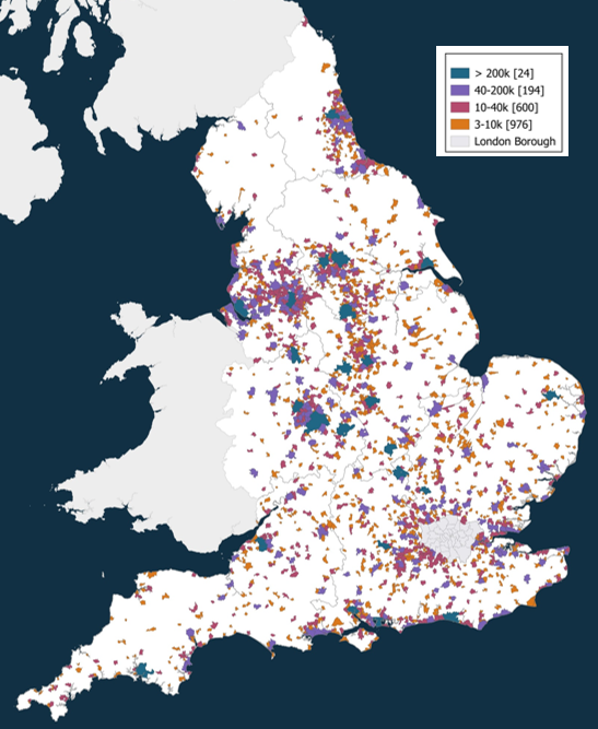
The spatial framework for the UEP Model covers 3,430 places with a population over 1,000, based on a best-fit assignment carried out by Didobi of Output Areas (OAs) to the 2022 Built-Up Area (BUA) boundaries defined for the 2021 Census (ONS), which ensures consistency and comparability between places.
For completeness the UEP Model also includes the 33 London Boroughs, which each represent a BUA, making a total of 3,463 places within the UEP.
Read or download the UEP one-page summary and methodology documents.
Understanding English Places
This work was carried out by Didobi Ltd (Matthew Hopkinson) and Edge Analytics Ltd (Julia Williams, Chris Duley).
For further information or to gain access to UEP please contact hello@didobi.com.